StoryMaps
Discover significant places in Minnesota history with the Minnesota Digital Library’s map exhibits. Each map features images, documents, and more from places throughout Minnesota. These primary and secondary sources come from MDL’s contributors from all over the state.
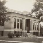
Carnegie Libraries Map
Explore this map to view a selection of the 66 libraries in Minnesota built with funds from Andrew Carnegie’s corporation.

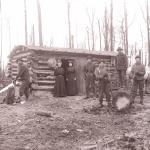
Civilian Conservation Corps Camps in Minnesota
The Civilian Conservation Corps (CCC) was a work relief program administered through the U. S. Army from 1933 through 1942. Minnesota's 148 camps had over 70,000 workers and were spread throughout the state. Explore this map to view a selection of the camps.
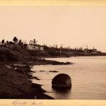
George Newton and His Photographs
George Newton lived and worked in northeastern Minnesota for over ten years. This map represents some of the many locations of his photographic work, including Duluth, along the North Shore, Ely, Tower, Biwabik, Isle Royale, and northern Wisconsin.

Going Up North: Hotels and Resorts in Minnesota
For over 150 years, people with the means and ability to travel have spent their summer vacations at scenic Minnesota lakes. Visit some of these historic vacation destinations using this map.
Minnesota Counties: From A to Y
Explore all 87 Minnesota counties through the collections of the Minnesota Digital Library – from Aitkin County to Yellow Medicine County. These six regional maps highlight one item from each county in the northwest, northeast, west central, east central, southwest, and southeast parts of the state.

Minnesota: An Ongoing American Experiment
In honor of America's 250th anniversary, this exhibit unpacks the principles of the Declaration of Independence and examines how they played out in Minnesota.
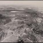
Minnesota's Iron Ranges
This collection of three maps shows the locations of mines in the Vermilion, Mesabi, and Cuyuna iron ranges of northern Minnesota, featuring historical photographs and documents.
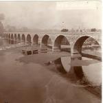
Mississippi River Map
This exhibit shows pictures, documents, and maps of several places along the Mississippi River in Minnesota from the Minnesota Digital Library.